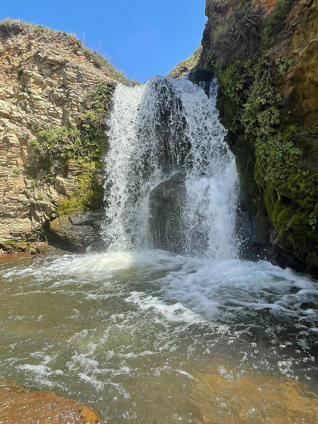
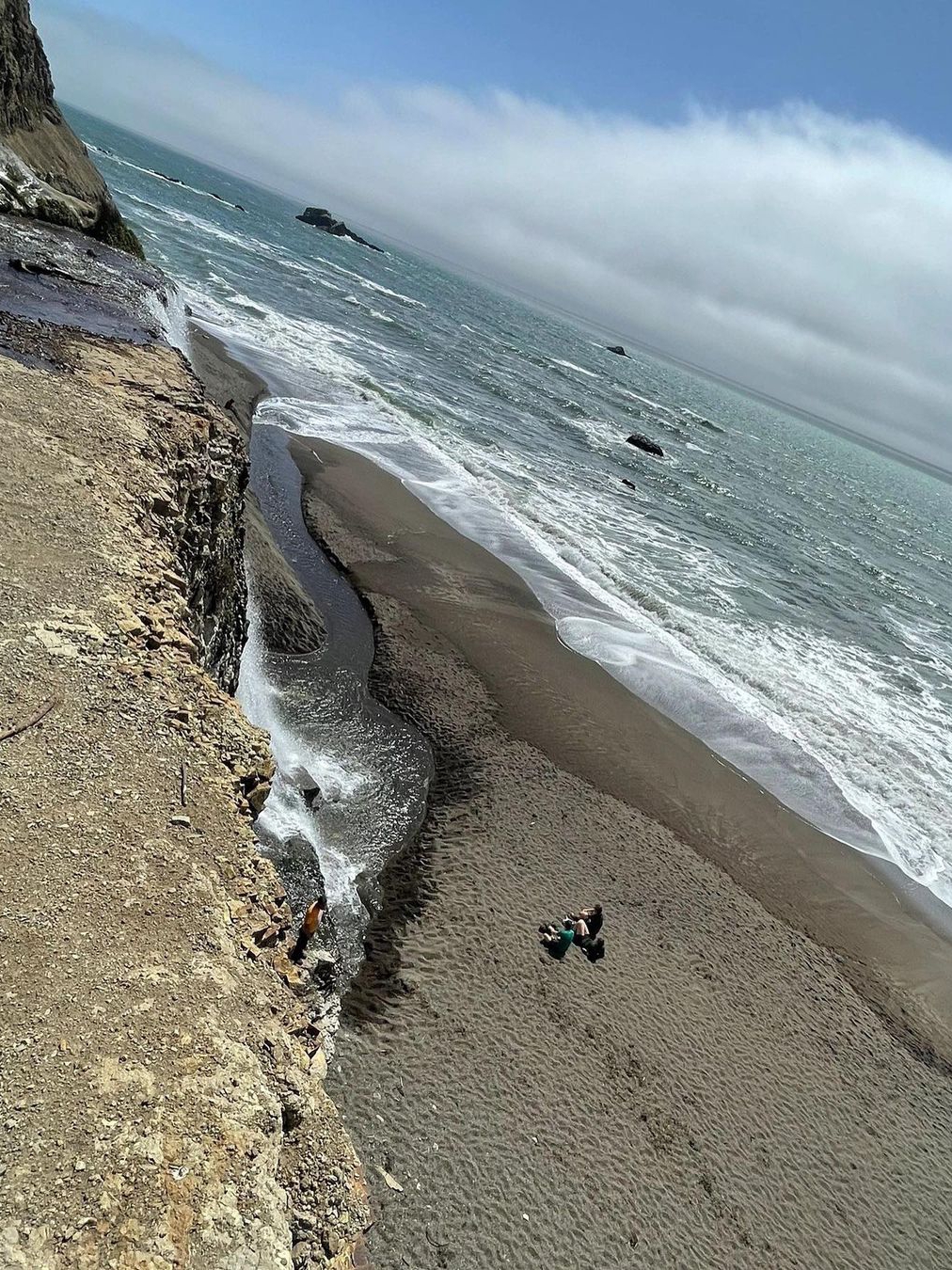
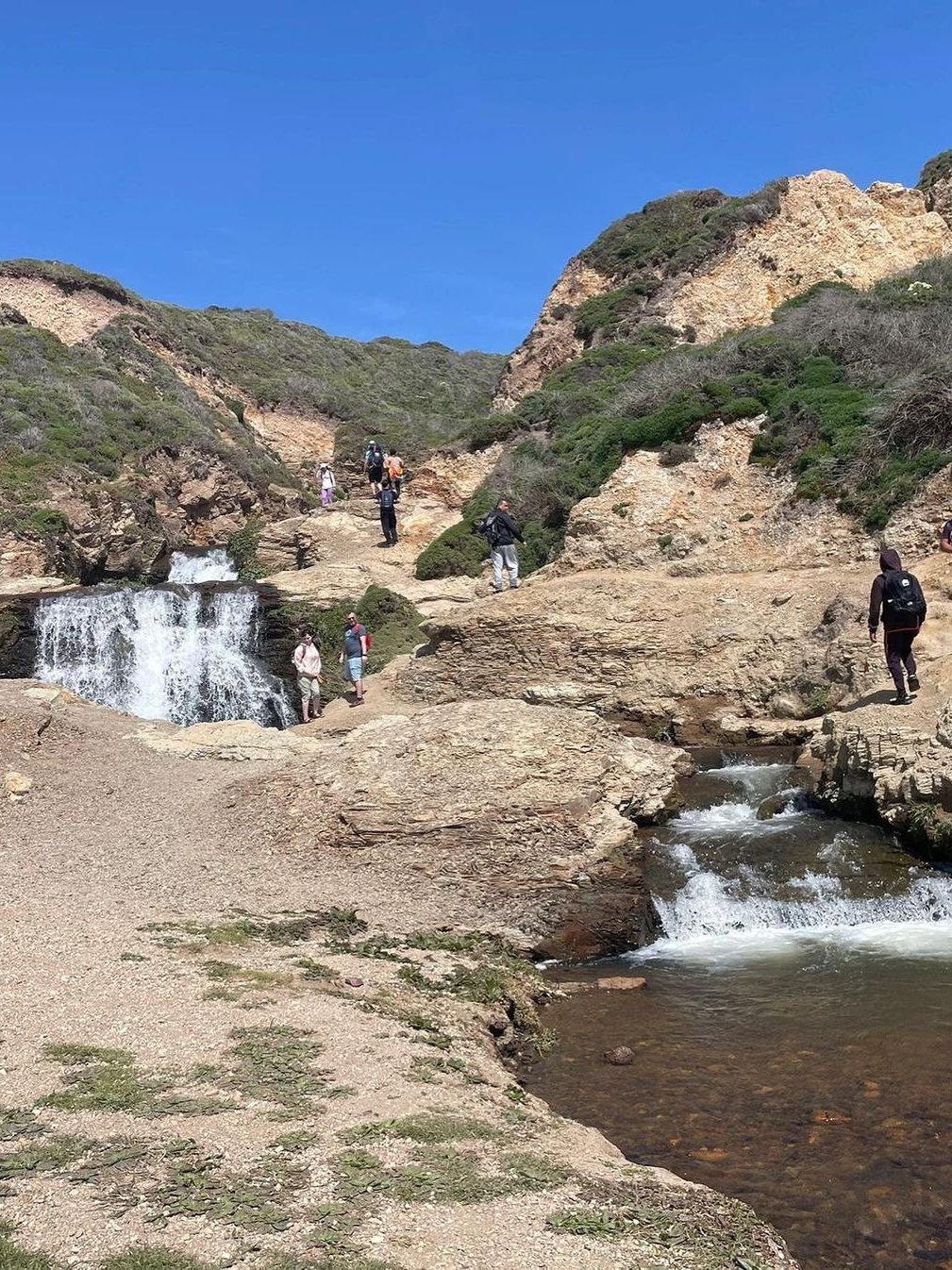
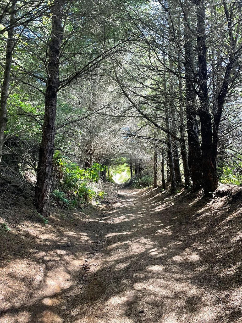
Tag Page BayAreaHiking

#BayAreaHiking
Christopher Gilbert

Bay Area Hiking | Summertime Forest Bath

In the scorching summer heat, apart from beach fun, you could go hiking in the mountains chock-full of redwoods. 📍 Muir Woods National Monument Mill Valley, CA Here, you can see some of the last remaining redwoods in the San Francisco Bay Area that weren't cut down in the late 1800s. The woods are full of towering trees, several centuries old and reaching up to 76 meters in height. The park has tons of trails for you to stroll amid the redwoods and really savor the unique natural scenery that the California redwoods offer. 🚗It's about an hour plus drive from the South Bay and you’ll need to reserve parking spots online in advance. $8.5 per car. 🎟Admission is $15/person (free for children under 15). The next free days are: 8/25 (Wednesday), 9/25 (Saturday), 11/11 (Thursday). 🌲Most of my photos were taken on the wooden walkways of the main trail which is 2 miles long, and round-trip is about 1 hour. It's pretty level, not too taxing, and perfect for beginners to hiking. 🌊Another famous trail is the Dipsea trail which is about three miles long, where you can be amongst the redwoods and enjoy the sea view. It's about a 2.5-hour round trip with a moderate level of difficulty. Tip: The park is full of tall redwoods, it’s mostly shady, and it may get chilly in the early morning and evening hours. So remember to dress warmly. Nearby is the Muir Beach which is a 10min drive. 📍Muir Beach Overlook, Muir Beach #BayAreaHiking #SummertimeForestBath #MuirWoodsNationalMonument #CaliforniaRedwoods #DipseaTrail #MuirBeach #ScenicViews #NatureEscape

Bay Area Hiking | Summertime Forest BathBay Area Hiking | Summertime Forest BathBay Area Hiking | Summertime Forest BathBay Area Hiking | Summertime Forest BathBay Area Hiking | Summertime Forest BathBay Area Hiking | Summertime Forest BathBay Area Hiking | Summertime Forest Bath
Mario Larsen

Discover Serenity at Cunningham Lake Native Garden Trail 🌿✨​

Craving nature without the crowds? Cunningham Lake Native Garden Trail offers the perfect getaway: 🌳 ​​Trail Highlights​​: Easy 2-mile loop (just 36 minutes to complete) Minimal foot traffic - true solitude guaranteed Peak season: September to July (current conditions ideal!) 🎯 ​​Perfect For​​: Quiet hiking, jogging or leisurely walks Family picnics with playground nearby Dog-free policy (bring your leash but leave Fido at home) ⚠️ ​​Visitor Tips​​: Weekend crowds increasing but ample parking available Avoid August for best experience Combine with nearby skate park/water park for family days This urban oasis delivers mountain-quiet just minutes from downtown San Jose! ​​Your take?​​ Found your new favorite escape yet? How do you unwind in nature? Share your favorite local trails below!👇 ​​#Sports #BayAreaHiking #SanJoseTrails

 Discover Serenity at Cunningham Lake Native Garden Trail 🌿✨​
Christian Russo

Discover Hidden Wetland Hiking Trails in the Bay Area

👀 Discover Hidden Wetland Hiking Trails in the Bay Area Embark on a hiking adventure at Martin Luther King Jr Regional Shoreline and revel in the beauty of nature. 🌿 Immerse yourself in the simplicity and tranquility of these serene moments, where you can just be and enjoy the scenery. 📍 Location: Martin Luther King Jr Regional Shoreline 🐶 Good news, dog lovers! You can bring your furry friends along on a leash. Here are some fascinating facts about this hiking spot: 1. The park spans over 741 acres and offers breathtaking views of the San Francisco Bay. 2. The wetland habitat is home to a diverse array of plant and animal species, including migratory birds. 3. You can explore a network of trails that wind through marshes, ponds, and grasslands. 4. Keep an eye out for wildlife sightings, such as egrets, herons, and even muskrats. 5. Don't forget to bring your binoculars to observe the various bird species that call this wetland their home. So, if you're in the Bay Area and looking for a peaceful hiking experience surrounded by nature's wonders, Martin Luther King Jr Regional Shoreline is the perfect destination. 🏞️🚶‍♀️🌳 #Hiking #BayAreaNature #WetlandExploration #TranquilAdventures #DogFriendlyTrails #BayAreaHiking #NatureSpotting #BirdWatching #MartinLutherKingJrRegionalShoreline #ExploreTheOutdoors

Discover Hidden Wetland Hiking Trails in the Bay Area Discover Hidden Wetland Hiking Trails in the Bay Area Discover Hidden Wetland Hiking Trails in the Bay Area Discover Hidden Wetland Hiking Trails in the Bay Area Discover Hidden Wetland Hiking Trails in the Bay Area Discover Hidden Wetland Hiking Trails in the Bay Area Discover Hidden Wetland Hiking Trails in the Bay Area Discover Hidden Wetland Hiking Trails in the Bay Area Discover Hidden Wetland Hiking Trails in the Bay Area Discover Hidden Wetland Hiking Trails in the Bay Area Discover Hidden Wetland Hiking Trails in the Bay Area Discover Hidden Wetland Hiking Trails in the Bay Area Discover Hidden Wetland Hiking Trails in the Bay Area Discover Hidden Wetland Hiking Trails in the Bay Area
Christian Russo

Tenzin Bhutti

🔍 Exploring More Kid-Friendly Hikes Around the Bay Area with Tenzin Bhutti (Part 2) 🚶‍♀️ 🌲 Kirby Cove Trail: This serene trail offers a unique view of the Golden Gate Bridge and is perfect for kids with its gentle slopes and picnic spots. 🌳 Dimond Canyon Trail: Experience the lush greenery and peaceful ambiance of this trail. It's relatively flat, making it an excellent choice for little legs. 🌊 Pillar Point Bluff Trail: A coastal gem with panoramic ocean views! It's a relatively easy hike, perfect for a family day out. 🏞️ Sanborn County Park: This park offers a variety of trails, each with its own unique charm. The Peterson trail is particularly popular among families. So, if you're looking for some outdoor fun with your little ones, these trails are a must-visit! 🥾 #BayAreaHiking #KidFriendlyHikes #OutdoorFun #NatureLovers #TenzinBhutti #KirbyCoveTrail #DimondCanyonTrail #PillarPointBluffTrail #SanbornCountyPark

Tenzin Bhutti
Mrs. Andrea Ayala

🌊🚶‍♀️ Bay Area | Coastline Hike Day Trip 🌲🌞

1: Getting to Alamerefall - Skip the long trek and head straight to Alamerefall with easy access to the parking lot. 2: Exploring the Coastline - Experience the stunning beauty of the Bay Area coastline. - Enjoy the perfect temperature and refreshing air. - The hike is relatively easy, but expect a 4-hour round trip. - Strong winds and gravel roads are common, so don't forget long pants, long sleeves, hiking shoes, and poles. - Make sure to leave your furry friends at home as pets are not allowed. - There are no restroom facilities along the way, so pack enough food and water. 3: Finding the Shortcut - Many people miss the shortcut route, resulting in a longer walk. - Look for the approximate location of the entrance on Google Maps. - The exact location is marked with an arrow in the last picture. Don't miss it! 4: Newbie-Friendly Adventure - This hike is perfect for beginners, allowing you to enjoy the beauty of the Bay Area's most picturesque coastline. Hashtags: #BayAreaHiking #AlamerefallAdventures #CoastlineExploration #HikeDayTrip #ScenicViews #NatureLovers #OutdoorAdventure #BayAreaBeauty #HikingTips #NewbieFriendly

🌊🚶‍♀️ Bay Area | Coastline Hike Day Trip 🌲🌞🌊🚶‍♀️ Bay Area | Coastline Hike Day Trip 🌲🌞🌊🚶‍♀️ Bay Area | Coastline Hike Day Trip 🌲🌞🌊🚶‍♀️ Bay Area | Coastline Hike Day Trip 🌲🌞🌊🚶‍♀️ Bay Area | Coastline Hike Day Trip 🌲🌞🌊🚶‍♀️ Bay Area | Coastline Hike Day Trip 🌲🌞🌊🚶‍♀️ Bay Area | Coastline Hike Day Trip 🌲🌞🌊🚶‍♀️ Bay Area | Coastline Hike Day Trip 🌲🌞
Christian Russo

Bay Area Hiking🏇 - A Hidden Gem Park Perfect for Spring Horseback Riding and Greenery Strolls

Hi, guys! I wanna recommend a trail route that I absolutely love, perfect for both horseback riding and walking. 💚 Name: Spring Valley to Los Coches Ridge Trail Loop 📏 Route Length: 2.3 miles 📍 Location: Spring Valley Trail, Milpitas, CA 95035 🕔 Operating Hours: 08:00–18:00 ⚠️ Note: No pets allowed 📍 Start of the Trail: - Navigate to the provided address for parking - Trail begins on the left side of the parking area, near a farmhouse and horses 🌳 Beautiful Scenery: - Walk along the fence and reach the top of the slope - Spot small buildings on either side and wildlife such as elegant egrets - Descend along a small dirt road and cross another road to reach a new trail 🌳 Shaded Path: - The first half of the trail is shaded by trees on the mountain's shaded side - Enjoy a refreshing walk with light and easy breathing 🐎 Horseback Riding on the Mountain Top: - Reach a flat area at the top, perfect for horseback riding - Stroll leisurely or let the horses run freely - Encounter fellow riders enjoying the experience 🌳 Tree Tunnel: - On the way back, experience a beautiful tree-lined path resembling the famous Tree Tunnel in Half Moon Bay 🅿️ Park Area: - The parking area also offers a small park with a pond and a large grassy area - Take a relaxing stroll if you have extra time #BayAreaHiking #HorsebackRiding #SpringNature #TrailAdventure #HiddenGem #Milpitas #OutdoorFun #ScenicViews #BeautifulTrails #NatureWalks

Bay Area Hiking🏇 - A Hidden Gem Park Perfect for Spring Horseback Riding and Greenery StrollsBay Area Hiking🏇 - A Hidden Gem Park Perfect for Spring Horseback Riding and Greenery StrollsBay Area Hiking🏇 - A Hidden Gem Park Perfect for Spring Horseback Riding and Greenery StrollsBay Area Hiking🏇 - A Hidden Gem Park Perfect for Spring Horseback Riding and Greenery StrollsBay Area Hiking🏇 - A Hidden Gem Park Perfect for Spring Horseback Riding and Greenery StrollsBay Area Hiking🏇 - A Hidden Gem Park Perfect for Spring Horseback Riding and Greenery StrollsBay Area Hiking🏇 - A Hidden Gem Park Perfect for Spring Horseback Riding and Greenery StrollsBay Area Hiking🏇 - A Hidden Gem Park Perfect for Spring Horseback Riding and Greenery Strolls
Robin Nichols

⛰️Trail Recommends | The Complete 10-Hour Hike to the Bay Area's Highest Peak

🏞️ Exploring the Bay Area's Highest Peak: A 10-Hour Hike ⛰️ 🌟Route Introduction: - Take on the Six Peaks Loop, a challenging 15-mile trail with a 4600ft climb. - This trail is recognized as a preparation route for Half Dome. - A group of us started the hike at 7:30am on December 24th and finished at 5:30pm, totaling 10 hours. - While I felt okay after the hike, my teammates, who don't exercise as much as I do, found it tough but rewarding. - Next year, we're planning to challenge Half Dome and Mt Whitney, and we agree that the Six Peaks Loop was excellent training. 🌟 Parking: - I recommend parking at Mountaire Parkway due to the parking lot at Mitchell Canyon opening at 8am and closing at sunset. - Slow climbers might risk being locked in if they park at Mitchell Canyon. - On our day, the sun set at 4:50pm, and we ended up running back to the car with flashlights on our cell phones. - Parking at Mountaire Parkway allowed us to make it back in time. 🌟 Climbing Process: - I highly recommend going counterclockwise on the loop (more on that later). - The first three peaks were not too difficult and we enjoyed them with laughter and jokes. - Diablo summit was more tiring, but the picturesque mountains along the way and the promise of ice cream at the summit kiosk kept us motivated. - Resting for half an hour, we continued to the last two peaks, which presented a challenge. - The route between North Peak and Mt Olympia is narrow, steep, and slippery, with overgrown vegetation. Be prepared to bend down to avoid tree branches frequently. - Hiking poles were essential in preventing slips, and we don't recommend doing the loop clockwise as the conditions for the second half are not as pleasant overall. 🌟 Lazy Route: - If you prefer a less challenging option, you can drive up to the summit. - The view from the top is average, but you can walk down towards the Devils Pulpit neighborhood for some beautiful photo opportunities. #BayAreaHiking #HikingAdventures #OutdoorExploration #SixPeaksLoop #MountDiablo #ScenicTrails #HalfDomePreparation #MtWhitneyChallenge #HikingTips #NatureLovers

⛰️Trail Recommends | The Complete 10-Hour Hike to the Bay Area's Highest Peak⛰️Trail Recommends | The Complete 10-Hour Hike to the Bay Area's Highest Peak
Mrs. Andrea Ayala

Bay Area Hiking with Blooming Wildflowers

Finally, the wildflower season in the Bay Area has arrived, and so, I made my way to the mountains to appreciate the blossoms. Compared to Northern Cali, the wildflowers here aren't as concentrated, but the beauty truly lies in their sparse, vivid orange specks scattered in a garden that reminds one of Monet. The best flowers are still found in the usual spots. As you walk along the Bayview trail, you'll first be greeted by white and light purple wildflowers, which when paired with the lush slopes really evokes a Monet garden vibe. At every turn, you come across a few poppies and as you go further along, the poppies seem to double until you arrive at the spot shown in the first picture. I used a 35mm focal length to take the pictures, which can usually be achieved with a standard smartphone or camera. While snapping away, remember not to step on the flowers and always be cautious of the steep slopes. In the afternoon around three, the wind along the trail suddenly picks up. I'd suggest checking out the flowers from ten in the morning till two in the afternoon. As this trail has minimal shade, remember to have your sun and wind protection on. Actually, coming out from the car park, you will also see poppies blooming on the mountain to your right. Walk further to a junction, and you'll find a little path leading uphill where you can enjoy the third picture's view. You can also find ice plants around the park. Besides the spots described above, there are many mountaintops filled with orange wildflowers waiting for your exploration. 🎫 Parking costs $5 per vehicle, cards are accepted. 📍Coyote Hills Regional Park 8000 Patterson Ranch Rd, Fremont, CA 📍Bayview Trail Flower Viewing Spot (37.5508223, -122.0976426) 📍Mountain Spot (Pic 3) (37.5503901, -122.0873979) 🅿️Car Park: The first car park you'll see when entering the park (37.5507524, -122.0857855) #BayAreaHiking #Wildflowers #BloomingSeason #MonetGardenVibe #NaturePhotography #CoyoteHillsRegionalPark #BayviewTrail #MountainSpot

Bay Area Hiking with Blooming WildflowersBay Area Hiking with Blooming WildflowersBay Area Hiking with Blooming WildflowersBay Area Hiking with Blooming WildflowersBay Area Hiking with Blooming WildflowersBay Area Hiking with Blooming WildflowersBay Area Hiking with Blooming WildflowersBay Area Hiking with Blooming WildflowersBay Area Hiking with Blooming WildflowersBay Area Hiking with Blooming WildflowersBay Area Hiking with Blooming WildflowersBay Area Hiking with Blooming WildflowersBay Area Hiking with Blooming WildflowersBay Area Hiking with Blooming WildflowersBay Area Hiking with Blooming WildflowersBay Area Hiking with Blooming Wildflowers
Christopher Gilbert

Bay Area Hiking to see the sea of lupines

The lupines are in full bloom on the hills in the Bay Area which you can admire while hiking. The spot where these flowers bloom in the Bay Area varies every year, and this year it is in the hills behind Berkeley. Once you park, you can see the trail entrance on the right. Ten minutes into the walk on the trail, you will see a small slope filled with clumps of lupines (Picture 4). Another 15-minute walk, and you can take a closer picture with a hillside filled with lupines (Picture 1). This spot offers a good angle for a selfie if you want one with the flowers. The view from the top of the hill is amazing. On one side you can see a bright blue reservoir and lush green slopes, and on the other, you can see the skyline of San Francisco obscured in the fog. There's also a small patch of lupines nearby. The lupines on the hill are different than what I've seen before. They used to be all clustered closely together, but here the flowers are scattered in bunches, like little tufts of grass. This is beneficial if you want to walk into the clusters to take offset photos without having to worry about stepping on the flowers. However, most lupines grow on steep slopes, so instead of taking selfies, it may be more fitting to climb the hill and enjoy the flowers. About 70% of this trail is shaded by trees, but it can get pretty hot so be mindful about sun protection and staying hydrated. The beginning of the trail is quite rocky and uneven, so sturdy hiking shoes are recommended. You can bring your dog, but strollers are not practical. The beginning of the hike is on the Big Springs Trail, and after about 20 minutes you'll reach the Seaview trail. 📍Big Springs Trail (37.8903384, -122.2319173) 📍Seaview Trail (37.8989848, -122.2409265) 🅿️ Tilden Regional Park - Big Springs Trail Parking Lot (S Park Dr, Orinda) #BayAreaHiking #SeaOfLupines #BloomingBeauty #BerkeleyHills #NaturePhotography #ScenicViews #TildenRegionalPark #HikingAdventures

Bay Area Hiking to see the sea of lupinesBay Area Hiking to see the sea of lupinesBay Area Hiking to see the sea of lupinesBay Area Hiking to see the sea of lupinesBay Area Hiking to see the sea of lupinesBay Area Hiking to see the sea of lupinesBay Area Hiking to see the sea of lupinesBay Area Hiking to see the sea of lupinesBay Area Hiking to see the sea of lupinesBay Area Hiking to see the sea of lupinesBay Area Hiking to see the sea of lupinesBay Area Hiking to see the sea of lupinesBay Area Hiking to see the sea of lupinesBay Area Hiking to see the sea of lupines
Steven Arnold

Bay Area Hiking: Discover a Mini Switzerland with Less Crowds

This trail truly lives up to its name, providing majestic views of the Bay Area's springtime valleys! My initial plan was to head to Sandy Wood Lake, but the road was closed, found this alternative trail instead. The effects of the recent heavy rain seem to have subsided, as most of the mountain trails have dried up. However, the grasslands remain lush, making it an ideal time to hike! The mountains here are not high, just a few minutes walk to the top. The vibrant green hillside is undulating and adorned with some houses, giving it a Swiss feel. Come spring, the wildlife begins to get active. I've encountered deer grazing on this trail before. Saw some birdwatching enthusiasts trying to get the perfect shot, so I decided to give it a try, hence photo number four. Overall, this trail is pretty easy to walk along as there aren't many slopes, nor are they too steep. The trail can be completed in approximately 20 minutes. Not a long one, but the scenery is delightful. The downside is that the trailhead section gets muddy when it rains. It's advisable to wear old dark-colored sports shoes or hiking boots. Near the entrance, there's a horse farm where many kids come to learn riding. The hill can be seen after passing the horse farm, and climbing it gets you to the top. The view from up here is terrific, and it's a great spot for photos. 🎫 $6/car, you can pay with cash or credit card 📍 Ed R. Levin County Park 3100 Calaveras Rd, Milpitas, CA 95035 📍Spring Valley Trail, Milpitas, CA 950 It's recommended to park till the trail head here 🅿️(37.4458980,-121.8474659) #BayAreaHiking #MiniSwitzerland #LessCrowds #SpringtimeValleys #HikingTrail #Wildlife #ScenicViews #EdRLevinCountyPark

Bay Area Hiking: Discover a Mini Switzerland with Less CrowdsBay Area Hiking: Discover a Mini Switzerland with Less CrowdsBay Area Hiking: Discover a Mini Switzerland with Less CrowdsBay Area Hiking: Discover a Mini Switzerland with Less CrowdsBay Area Hiking: Discover a Mini Switzerland with Less CrowdsBay Area Hiking: Discover a Mini Switzerland with Less CrowdsBay Area Hiking: Discover a Mini Switzerland with Less CrowdsBay Area Hiking: Discover a Mini Switzerland with Less CrowdsBay Area Hiking: Discover a Mini Switzerland with Less CrowdsBay Area Hiking: Discover a Mini Switzerland with Less Crowds